

How do polar researchers actually find the measuring stations and sensors they have deployed on the sea ice after they have recorded data independently for days, weeks or even a year? On land, it’s easy – you use GPS to determine the exact position and reliably find the devices in the same place. However, sea ice is a mobile environment and once coordinates have been stored, they are of little help in locating instruments. In addition, there are no visual clues to use for orientation, as the surface of the sea ice is also constantly changing. Martin Schiller, a sea ice technician at the Alfred Wegener Institute for Polar and Marine Research, had to make this experience during an hour-long search operation in 2016. Schiller then looked for a solution and, together with colleagues, developed a sea ice app.
Martin Schiller’s invention, the FloeNavi app, arrived after a three-year development phase just in time for the start of the MOSAiC expedition in autumn 2019. The app is based on the Automatic Identification System (AIS), which has been used in shipping for over 20 years, among other things to avoid collisions. The system continuously broadcasts the position coordinates, course, speed and information about the ship to the world via VHF so that other ships can react accordingly.
“As a research icebreaker, Polarstern naturally had her own AIS transmitter and receiver, which gave me the idea of basing the coordinate system for the floe on AIS transmitters.”
Martin Schiller, sea ice technician at the Alfred Wegener Institute for Polar and Marine Research
It quickly became clear to Schiller that this system is exactly what polar researchers need when working on sea ice. The sea ice moves on the ocean below along currents and also rotates on its own axis. And everything on the sea ice moves with it. Coordinates noted at a point in time therefore only reflect the correct location at the moment of positioning, as they always refer to the earth’s surface, in this case the ocean floor.
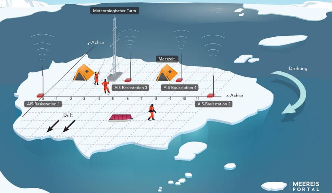
To translate the AIS onto an ice floe, all that is needed is a coordinate system that is projected onto the floe. For this purpose, it is only necessary to anchor two transmitters, which mark the X-axis, at a defined distance on the ice. The projection of the Y-axis is done by software, which also processes the continuously transmitted position data from the two AIS base stations and calculates the exact position of the coordinate system.
Schiller developed an AIS box for marking measuring stations or the course of measuring routes, which the scientists take with them onto the sea ice. The box contains an AIS receiver and a WLAN hotspot that transmits the data to a tablet. On the tablet, the scientists then use the FloeNavi app to display and save their exact position on the floe. However, the app can do even more: each research team can select its measuring instruments from a list, so that ice core drillings, piloted ROV dives, weather balloon or snow temperature measurements can be digitally documented. All position, time, device and action data recorded in this way are then automatically fed into the data network of German research shipping (D-Ship) from the research icebreaker Polarstern and archived.
“We were able to use the FloeNavi system from the outset to record it whenever we used instruments on the floe, instead of – like we used to – typing it into our personal field logs back on board so that we had a digital record.”
Dr. Marcel Nicolaus, marine researcher at the Alfred Wegener Institute for Polar and Marine Research
Tests on the Weser ferry and Finnish fast ice (sea ice frozen onto the coast) were not very meaningful, as the speeds of the test platforms could not be compared with those of drift ice. Therefore, the only option was the endurance test in the Arctic during the MOSAiC expedition. Initially, the position calculation did not work precise enough and there were tiny flaws in the software. Nevertheless, the scientists used their new tool successfully from the beginning of the expedition. In parallel, experts in Bremerhaven worked on fixing the technical problems so that the improved version could still be used in the course of the year-long expedition.

Above all, the new documentation method saves the scientists a lot of time and work, which is why the app is also to be used for other types of expeditions. For this purpose, the Data Logistics Support Team of the AWI Data Center has further developed the app and given it a new name: “Mobile ActionLog App”. Depending on the pandemic situation, the new app will be tested in practice in the North Sea in the second week of May.
However, the FloeNavi app will have to wait a little longer for its next use: “It’s only worthwhile setting it up if we’re going to spend several days on an ice floe during an expedition and several different devices will be used. But when an ice station like this is planned, we’ll once again install the tried and trusted AIS coordinate system,” says Martin Schiller.
Julia Hager, PolarJournal
More on the subject:


