
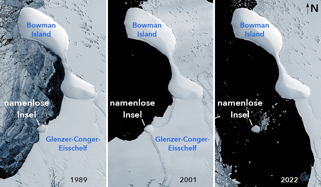
Where snow and ice cover the landscape and the ocean, some things underneath remain hidden. But since globally rising temperatures are gnawing more and more at the frozen masses, causing them to collapse in some cases, previously unknown islands or other landscape features are being exposed. This was also the case in East Antarctica, where the Conger Ice Shelf collapsed about six weeks ago. Scientists discovered on satellite images something that must be an ice island.
The ice mound was already visible on satellite images more than 30 years ago, while it was still embedded in the then intact Conger ice shelf. But until its collapse, it was not clear whether the mound is an island or not. However, since it has not changed its shape and is still in the same place, although large icebergs certainly crashed against the almost round white mound when the ice shelf collapsed, scientists assume that it must be an island.
In addition, elevation measurements with the Advanced Topographic Laser Altimeter System (ATLAS) on NASA’s ICESat-2 suggest that the ice mound is as much as 30 to 35 meters above the sea surface.
But even if the signs speak for an island, this does not mean that the mound is an island in the conventional sense. Scientists still can’t say for sure whether, under all that snow and ice, solid bedrock breaks through the ocean’s surface.
However, according to John Gibson, a scientist with the Australian Antarctic Division, it is likely to be an ice island: a large, heavy ice cap sitting firmly on an underwater peak. “It is undoubtedly similar to other ice islands, such as Bowman Island,” Gibson says.

For now, the still-unnamed ice island is self-sustaining, Gibson explains. This means that melting processes under water are compensated by new accumulations of snow and ice on the surface. However, if this balance is disturbed by a decrease in precipitation or surface melting, the ice island could thin and float away. “The unnamed island is a more-or-less permanent feature of the landscape,” Gibson said, “but may someday detach from the underlying rock and become an iceberg.”
So far, no one has taken a close look at the new island, so its exact structure remains a mystery. “To be absolutely sure, you would need to put a ship next to it to check for a bedrock outcrop, and maybe a radar over it to assess the ice thickness,” said Christopher Shuman, a glaciologist at the University of Maryland, Baltimore County, at NASA’s Goddard Space Flight Center. “The ICESat-2 profile shows that the surface is well above sea level. That would be a whole lot of ‘ice cream’ above the ‘cone’ if there wasn’t bedrock at or above sea level.”
The new island is not the only one that has appeared in the recent past after the loss of ice shelves. These include, for example, Icebreaker Island, which was isolated from the Larsen B Ice Shelf on the Antarctic Peninsula in 1996, or a small ice-covered rock island discovered by scientists during an expedition in 2020 that may have been part of the ice shelf of Pine Island Glacier in West Antarctica.
“The discovery of more of them is likely to continue in the years ahead due to shrinking glacial and sea ice,” Shuman said. “Obviously these are ‘new to us’ features, but we also have more people and more tools to look at the margins of Antarctica now. Several examples do not make a trend, but they do imply that other once-hidden features are likely to be noticed in the years to come.”
Julia Hager, PolarJournal
More about this topic


