
New timeline to remove clay at perilous Pretty Rocks site pushes completion date for bridge and full park road access to 2026
By mid-summer in 2026, visitors will likely be traveling over a sophisticated new bridge that clears a geologic hazard that has become a poster child of climate change in Alaska. Until then, the National Park Service and the tourism industry will be coping with three more years of shutdowns at about the halfway point of the sole park road to avoid ongoing landslides at a steep and perilous site called Pretty Rocks.
Where there used to be a curve at about the halfway point of the 150km road, a site known for its spectacular views of a valley called the Plains of Murie, a section of road is now gone, leaving a nearly sheer drop-off in its place. When the sun hits the rock face on the north side, as it did on the first Friday in May, clumps of dirt and rock tumble almost incessantly down the slope.
In August of 2021, the road was closed there; that section was still intact but deemed too dangerous for public travel. By then, the perils were obvious, according to Dave Schirokauer, the science and resources team leader for Denali National Park. He pointed to a site on the now-collapsed road section. “Right over there in the corner, we could see ice. Very, very ice-rich permafrost was at the surface and was very visible,” he said during a 5 May tour.
Pretty Rocks got this way in Hemingway-like fashion: gradually, and then suddenly. The slope was moving slightly in the 1960s and likely for decades earlier, according to the park service. But, prior to 2014, it was causing little trouble beyond some occasional small cracks in the road surface, according to park officials. As the climate continued to warm, slope movement that was measured in centimetres per year before 2014 increased to centimetres per month in 2017, centimetres per week the following year, centimetres per day in 2019 and, in 2021, nearly 2cm per hour, according to park officials. A collapse in August of 2021 forced the abrupt road closure and an early end to some Denali trips.
The project to reopen the road at Pretty Rocks, expected to cost about $100 million (€94 million), is challenging. The site is remote and steep. The bridge has to be suitable for permafrost terrain, strong and secure enough to carry tour busses and withstand earthquakes, subtle enough in appearance to blend in with surroundings and constructed in a way that minimises impacts to park visitors and wildlife.
The design includes anchors to lodge vertically and at angles. It also includes 23 thermosyphons — devices that pull heat out of the ground — to preserve a pocket of ice-rich permafrost discovered 85 feet below the surface at the east end, said Steve Mandt, the park engineer co-ordinating the project.
Site geology pushes back road opening
The site’s geology makes any fix complex. There is permafrost overlain with a rock glacier, which is a frozen but thawing conglomeration of rock and ice. There is clay, which thaws at a lower temperature than that needed to melt ice. There is rainwater that infiltrates all that and, depending on the season, expands the ice or hastens the melt. “So you’ve got rock, you’ve got rain that freezes and you’ve got this major ice layer that’s moving,” Mr Schirokauer said.
The clay has proved particularly problematic. A recent discovery that workers will have to remove 60,000 cubic metres of clay on the west side of the planned bridge site rather than the 20,000 previously estimated means a one-year delay in the project’s expected completion, said Sharon Stiteler, the park’s spokesperson.
The change from a 2025 road opening is a setback to the tourism industry.
“With the additional delay, obviously, that is disappointing,” said Jillian Simpson, president and chief executive officer of the Alaska Travel Industry Association. But the road is “a critical piece of infrastructure” and the industry understands “how important it is to get it right,” she said. “Denali is the linchpin of tourism when it comes to exploring Alaska on land.”
As the bridge becomes reality, Denali will be busy with more than the usual tourist crowds.
A camp at the park’s gravel site operated over the next summer seasons will serve 50 or more workers who will shuttle back and forth, their vehicles in some places alternating with the tour busses.
The approach to the Pretty Rocks site is so narrow that work trucks are to be backed in because there is not enough space for large vehicles to turn around. There will be some noise, like from pile driving, though the plan is to keep that to a minimum.
For tourists, this will be another year of stopping at the site called East Fork at the road’s halfway point where there is a temporary ranger station in a yurt and enough space for busses to turn around.
“This is the new Eielson,” Mr Schirokauer said, referring to the temporarily closed Eielson Visitors Center, normally a popular stopping and turnaround site.
Last year, the first full year of the closure at Pretty Rocks, the number of visitors bounded back from extreme lows resulting from the Covid-19 pandemic, though it was still only 88% of typical pre-2020 levels, according to an analysis by the Alaska Department of Labor and Workforce Development, a state agency. Those who came to Denali were curious about the landslide, park employees said. Many who rode the bus as far as they could, to the East Fork turnaround, walked the extra distance to see the site for themselves, according to Ms Stiteler.
This year, with Alaska on track for a record 1.6 million cruise passengers, the crowds are expected to be bigger. But Denali should be able to handle the increased traffic, even with half the road closed, according to Brooke Merrell, the park’s superintendent.
“We feel like we got a good practice year last year to make sure we have it right,” she said. “We believe we’ll be able to accommodate it with the part of the road we have this year.”
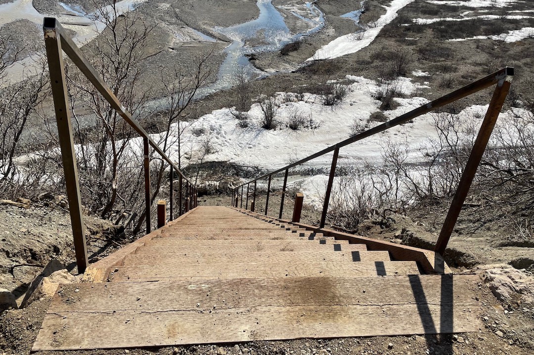
It remains possible to travel around Pretty Rocks to the western half of the park. There is temporary access provided by a steep stairway from the East Fork bus terminus to the river valley below. About 15% of the visitors who rode the shuttle bus that far last year chose to make that descent for brief walks or even more extensive hikes, according to park staff.
Backcountry users with the appropriate permits can keep going from there to explore the territory that is currently beyond park road access. Well-heeled travellers can, moreover, fly into Kantishna, the patch of private land at the end of the road, and stay at deluxe lodges where rates are well above $1,000 per day.
The tourism industry has been adjusting to the new reality. For local companies, last year was a “mixed bag”, with some operators able to take advantage of increased traffic resulting from the shorter bus trips but others struggling, said Vanessa Jusczak, of the Denali Chamber of Commerce, based in Healy. Excursion companies had more business, but short-staffed restaurants were burdened by crowds appearing at what were normally low-volume times, she said by e-mail.
In Anchorage this summer, people planning to visit Denali appear to be well aware of the road closure, said Jack Bonney, vice-president of the Anchorage Convention and Visitors Bureau.
“It doesn’t seem to be affecting their choice about whether they go to Denali or not,” he said. While “the closure is in the back of people’s minds”, the park continues to be seen as an attractive destination.
The road closure isn’t just affecting human activity. The park service is embarking on a study of bears to what impact the lack of road traffic might be having on them, Mr Schirokauer said. The plan is to collar 18 to 20 animals, with half on the east of Pretty Rocks and the other half on the west side where the road is closed, he said.
While Pretty Rocks is a dramatic and visible case because of its location and the inconvenience it is causing, thaw-induced landslides are increasing all over the North. Within the Denali road corridor, more than 140 landslide-prone sites have been identified.
Along other roads in Alaska, there are dangers in other national parks and sites outside of parks. Those include Slate Creek along the Parks Highway, just outside Denali’s entrance, where permafrost thaw appears to be combining with extreme rainfall to create potential maintenance headaches and threats to a recently installed fibre-optic cable and other infrastructure, and the Dalton Highway, the sole land route to the North Slope oil fields, where thawing “frozen debris lobes” of ice, dirt, rock and vegetation are creeping downslope and forcing diversions and adjustments. East of Alaska, in Canada’s Northwest Territories, thaw-triggered landslides and slumps are eating away at the Dempster Highway.
Away from roads, big hazards come from thawing mountainsides, especially of coastal mountains, where dumped debris can cause localised tsunamis. One landslide hotspot is northern South-east Alaska, where tall peaks rise dramatically from glacial fjords. There, and in neighbouring parts of Canada; the pace of landslides is accelerated through combined glacial retreat and mountain permafrost thaw that destabilises slopes.
In 2015, in Taan Fjord, a coastal area of Wrangell-St Elias National Park, the side of a mountain collapsed, sending rocks and debris into the water and triggering a local tsunami that reached almost 200m, making it the fourth highest ever recorded. No-one was affected by that, but the story was different in Greenland in 2017, when a massive landslide in a glaciated area caused a tsunami that killed four people.
In Denali, the Pretty Rocks bridge will not be the end of the work. The federal funding secured for the bridge is also intended to cover a second project phase to address another unstable site less than a mile to the east called Bear Cave.
Yereth Rosen, Alaska Beacon
Alaska Beacon is part of States Newsroom, a network of news bureaus supported by grants and a coalition of donors as a 501c(3) public charity. Alaska Beacon maintains editorial independence. Contact Editor Andrew Kitchenman for questions: info@alaskabeacon.com. Follow Alaska Beacon on Facebook and Twitter.
More about this topic


