
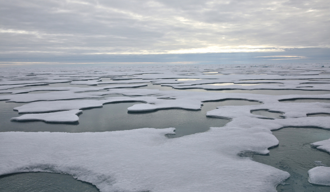
In mid-September, the eyes of the world are focused on various research institutes dealing with global snow and ice data. Data on the annual sea ice extent in the Arctic, from the world’s fastest-warming region, are eagerly awaited. This year, the tension was particularly high, as record temperatures, early ice melts and massive fires in spring and summer in various areas of the Arctic had made headlines. Now the data are on the table and show that the extent of sea ice has reached the second lowest amount since the start of the records.
Both the German Alfred Wegener Institute AWI and the University of Bremen, as well as the US National Snow and Ice Data Center, reported an expansion of 3.74 – 3.80 million square kilometers of ice in the Arctic in mid-September. This is only about 500,000 square kilometers above the negative record of 3.27 million square kilometers in 2012. While the areas between Canada, East Greenland and the North Pole look like a closed ice cover at first glance, satellite measurements of the ice concentration showed that large parts had only a weak concentration of sea ice and that the Arctic coasts from the US over the Russian Arctic Islands to Svalbard were completely free of ice very far up north. The otherwise year-round coastal areas of northern Greenland, covered with thick sea ice, also only showed a thin concentration of ice. The MOSAiC expedition, led by the AWI, discovered only large pattern of ice and water surfaces at the North Pole instead of a closed ice cover.

The published data is not a real surprise. As early as spring, satellite and field measurements in the Russian Arctic had recorded very thin sea ice, which had also quickly broken up and disappeared. As a result, the sunlight was able to warm up the water as early as March. The stored heat was then driven north with winds and intensified the melting. Along the Russian coastal water, the Barents Sea and the Chukchi Sea, the water temperature on the surface was up to 4.5 degrees above average. “We assume that due to the stable high pressure area over the central Arctic in July and August, there were significantly more cloudless days,” says Dr. Monica Ionita, a climatologist at the AWI. “As a result, the incoming solar radiation, which would otherwise be reduced by clouds, was also able to contribute to the melting of the ice this year.”

In addition, the melt was enhanced by unusually high air temperatures in May and June in large parts of the Russian Arctic. “This heat initially melted the thin sea ice in the Laptew Sea, then accelerated the retreat of the ice in the East Siberian Sea, so that the Russian Arctic already had about one million square kilometers less sea ice in June of this year than in the previous seven years,” explains sea ice physicist Professor Christian Haas of the AWI. The participants of the MOSAiC expedition also recorded higher temperatures than normal in the central areas of the Arctic, up to 6°C. These warm air masses and the resulting wind changes (including a very severe storm in the Canadian Arctic) had caused the ice cover to break apart. At the same time, measuring buoys recorded higher water temperatures on the surface, caused by water masses that normally occur at a depth of 150 metres. In wintger, they had already provided thinner ice than normal. This pre-programmed a faster meltdown in spring and summer. So the question was not whether a below-average year would be achieved, but only how much it would be. The answer, which traditionally is provided between mid-to-late September, continues to go downwards.

Dr Michael Wenger, PolarJournal
More on the subject:


